OUR Services
Hydrographic Surveys:
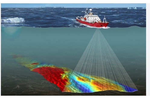
Seascape Technology delivers specialized underwater hydrographic surveys using advanced sonar and magnetometry scanning. These high-precision techniques provide critical seabed mapping and object detection, essential for the safe planning and execution of underwater construction projects such as pipeline and cable installations, port/jetty/land developments as well as for locating lost anchors, anchor chains, vessel parts, or other submerged objects. Our surveys give you the accurate data needed to make informed decisions and ensure project success.
Underwater hydrographic surveys involve mapping and measuring the underwater environment, including the seafloor and water column. This can include:
- Bathymetric surveys: Measuring the depth and topography of the seafloor
- Seafloor characterization: Identifying the type and composition of the seafloor
- Water column surveys: Measuring water properties, such as temperature, salinity, and currents
Sonar (Sound Navigation and Ranging) and magnetometry scanning are common techniques used in underwater hydrographic surveys.
- Sonar: Uses sound waves to measure the distance and topography of the seafloor
- Magnetometry: Measures the magnetic field of the Earth and detects anomalies caused by subsurface features or objects